


An example of system application software relates to TSPIGII. In this case, the software incorporates communication routines and math functions to derive a solution (TSPI); and then use it either to control a vehicle based upon the data (as in guidance and control), or to display the data to an operator, or to save them (on-board TSPI storage) for post processing and analysis, or to transmit them (down link the TSPI) to a receiver.
A front end software loads the sensor calibration parameters in flash file called syspar. It is an interactive program, which prompts the user to enter the calibration parameters related to the scale factors, the biases and the standard deviations. A second part of the program saves the information required to start the Kalman filter in a file called IC0_dat.
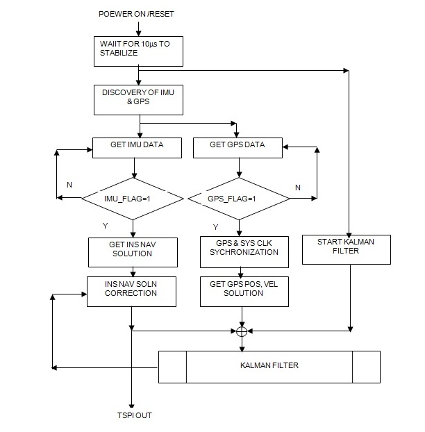
Upon a reset or power on, the IMU and GPS modules go through a self-check and initialization. When valid data are available, their respective flags are set high. The system clock is synchronized with GPS clock. The Kalman filter is started. It gathers data from both the GPS and INS path and provides a corrected update of the nav solution. This solution is fed back to the INS for correctional update. The updated INS solution is the integrated TSPI of the system.
The basic modules of the application software include:
TSPIGII power-on initialization
communication with the GPS module using the Binary messages through Serial port 1
communication with the GPS module using DGPS corrections via the Serial Port 2
communication with ADS to acquire sampled inertial sensor data
GPS/Inertial solution integration
Built-in Tests
Interrupt service routines for different peripherals
TSPIGII communication protocol and service routine with outside world
Another extension of the application software may include correlation of TSPIGII data (the vehicle orientation and position) to local landmarks on the ground and construct a video composite for the operator to visualize.
The wireless methane monitoring system records the concentration of the gas at various locations in the sensing network in a Host management computer.
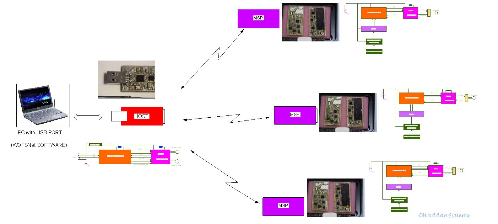
This software application manages all the tasks of communication between the host module and the gas sensing node. It is designed in a modular form to perform the following functions:
Sending and receiving of data
Identifying various Gas Sensing Node link address inquiries
Connection set up
Authentication
Diagnostic
Gas Sensing Node discovery and wakeup
Whenever the host module is plugged into the USB port of the Host management computer, it establishes a communication protocol, that includes a GUI to monitor the entire gas sensing network so that the real-time output of each gas sensing node is displayed on the Host computer screen.
An additional system application module in this case correlates the sensor data with its corresponding geographical location, and prepares a methane distribution map for transmission to the methane mitigation team or for distribution over the Internet to the designated users or locations e.g. a display in the elevator or a display with maintenance supervisor etc.
